A named valley and trailhead
New Zealand · LIFE LISTFirst-visit notes
Life List · First-visit field guide
Mount Aspiring National Park
Choose one Mount Aspiring valley from Wānaka or the wider Queenstown region before choosing a walk. Matukituki day walks and the Rob Roy viewpoint differ from remote alpine routes in road access, river and avalanche exposure, and the skill needed to turn around safely.
Why it belongs on the listWhy it belongs on your Life List
What makes this place worth a lifetime detour
Life List status is about an experience that is difficult to substitute, not simply popularity.
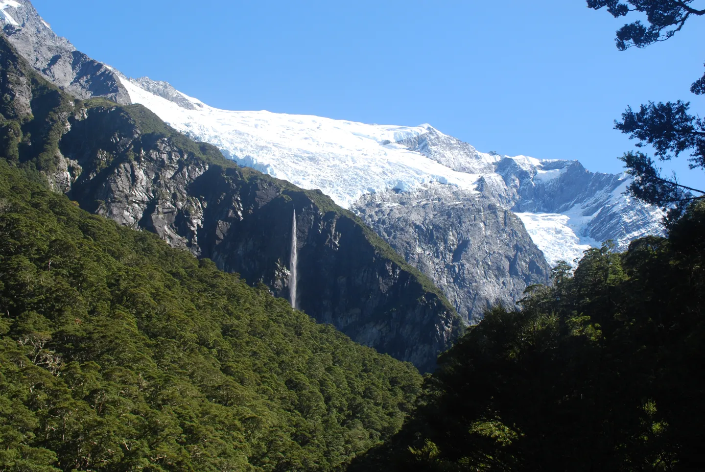
Mount Aspiring/Tititea is a Life List landscape because its river valleys, beech forest, hanging glaciers and alpine routes show the Southern Alps beyond a roadside viewpoint. A first visit is complete when the route is chosen honestly for the conditions, not when a summit is claimed.
Signature experiences
The experiences that define this park
These are representative experiences, not a promise that every activity will be available under current conditions.
- 01
Walk a Matukituki valley trail with the road and river conditions understood
- 02
View the Rob Roy glacier from a DOC-approved lookout when conditions allow
- 03
Notice the shift from pastoral approach to protected beech and alpine country
- 04
Learn which routes require genuine backcountry skills and overnight logistics
What counts as a complete first visit
A satisfying first completion, not an exhaustive conquest
Use this as a collection-minded benchmark while allowing weather, access, safety, and local rules to change the exact itinerary.
A DOC alert and road-ford check
One walk finished within the current safety advice
A weather alternative that does not require crossing a risky ford
First-visit verdict
Decide the shape of the trip before the bookings
This page is durable planning context, not a live conditions feed. Recheck every authority before departure.
Best planning window
Warmer months generally make first-visit valley walks more approachable, but rain, road fords, alpine weather, track alerts and avalanche exposure must be checked for the specific route and date.
First visit
One deliberate valley walk plus an access or weather margin; multi-day hut routes need their own itinerary
Gateway logic
Wānaka is the practical base for Matukituki Valley. The national park also reaches Makarora and the Routeburn area; these are separate road approaches, not one continuous drive-through sightseeing loop.
Reservation pressure
Moderate
Effort
Moderate-high
Primary caution
Flooded road fords, swift rivers, steep drops, rapid alpine weather and avalanche paths on some tracks
Trip fit
Who this park suits
Match the access model and pace to the travelers, not only the scenery.
Good fit
- Walkers who want a valley-to-alpine landscape
- Wānaka-based travelers prepared to check gravel-road and ford conditions
- Experienced trampers who choose a route matched to conditions and equipment
Less suitable when
- A promise to reach Mount Aspiring/Tititea summit on a casual first visit
- Driving through water crossings without a road or weather check
- Applying summer day-walk advice to avalanche-season tracks
Transport fit
- Self-drive or arranged transport to a named valley and trailhead
- DOC hut and campsite booking when the chosen route requires it
- Route-specific backcountry transport for multi-day tramping
Priority order
Build the first visit around these decisions
Keep the plan credible before adding optional stops.
- 01
Choose Matukituki, Makarora or a Routeburn-side objective before choosing accommodation or a trail.
- 02
Check DOC’s current Rob Roy Track and Matukituki road advice; the final road section has gravel and ford crossings.
- 03
Treat lower and upper Rob Roy viewpoints differently in avalanche season; DOC advises against continuing past the lower lookout from May to November.
- 04
Use DOC hut booking and current track conditions for any overnight route instead of extrapolating from a day walk.
Planning decisions
Make the high-friction choices explicit
These are the decisions most likely to change the shape of a first visit.
Choose a valley before the trail
DOC describes Mount Aspiring as a large, relatively undeveloped national park with distinct Matukituki, Makarora and other access areas.
- Wānaka is the useful Matukituki base, but the park is not one compact attraction.
- Name the trailhead and exact road before planning daily walking time.
- Separate a valley walk from a hut, alpine or mountaineering route.
Rob Roy is a viewpoint walk with a seasonal limit
The DOC track reaches glacier viewpoints via a bridge and forest climb; steep drops and avalanche paths mean the upper section is not an all-season default.
- Use the current DOC track page and visitor-centre advice before departing.
- From May to November, DOC strongly recommends stopping at the lower lookout due to avalanche exposure above.
- Do not continue beyond the upper lookout into unstable terrain.
The approach can be the day’s limiting factor
The road from Wānaka to the Raspberry Creek area includes gravel and several fords that can rise after rain.
- Check road and rainfall conditions before the drive.
- Never assume a rental vehicle is permitted to use unsealed roads or fords.
- Use arranged transport or choose a different walk when water or vehicle suitability is uncertain.
Overnight tramping is a separate plan
DOC huts, rivers, snow and remote communications call for route-specific skills and booking checks.
- Check the exact hut and track rather than assuming every DOC facility uses the same booking system.
- Carry a suitable navigation, weather and emergency communication plan.
- Respect private farmland and livestock on the approach to the park.
Common mistakes
What makes a first visit harder than it needs to be
Assuming a park name corresponds to a single entrance or easy paved loop.
Driving into a flooded ford because the trailhead looked close on a map.
Continuing past a signed lookout into unstable terrain for a closer glacier photograph.
Treating Cascade Saddle or a high alpine route as an extension of a family-friendly valley day.
Wildlife, safety, and care
Leave certainty out of the plan
Weather, wildlife, roads, closures, reservations, and local operating rules can change.
Wildlife and safety
Observe native birds, including kea, without feeding them or leaving food and equipment exposed.
Conservation
Stay on marked tracks, leave farm gates as found, clean gear between waterways, protect alpine vegetation and carry all waste out.
Useful next steps
Use the right official or booking doorway
Official rules and availability are separate from a general accommodation search.
Check DOC Rob Roy Track and access
Review current lookout, avalanche, ford and road guidance before a Matukituki day.
Open official siteReview DOC facility bookings
Check whether the exact hut or campsite on an overnight route requires a reservation.
Open official siteSearch Wānaka accommodation
General stay search only; confirm the actual trailhead approach and vehicle conditions.
Open platformBefore departure
Recheck what can change
Do not rely on a saved itinerary for operating conditions.
- 01
DOC Mount Aspiring and Matukituki alerts
- 02
Rob Roy Track and avalanche advice
- 03
Road ford levels and vehicle restrictions
- 04
Rain and alpine forecast
- 05
Hut or campsite bookings for any overnight trip
Related decisions
Use the park in a real trip decision
These guides compare access, pacing, transport, or trip structure without duplicating this park-level guide.
Fiordland Day Walks or a Great Walk?
Compare a flexible Lake Gunn or Key Summit day with a booked multi-day Milford, Kepler or Routeburn itinerary.
Open decision guideKeep comparing
Mountains & Glaciers
Altitude, weather, roads, shuttles, hiking seasons, and multi-day pacing.
Regional field guide
New Zealand Alpine Parks: Fiordland and Mount Aspiring
Choose Te Anau for Fiordland or Wānaka for Mount Aspiring, then plan a Milford Road, valley walk or booked multi-day track with its own weather and access rules.